Last week I got an emphatic reminder of how helpful, perhaps even critical, it is to utilize Active Captain. I was in Annapolis for a survey, representing the buyer on a 35′ Island Packet. As is my custom I always tote along my iPad with Active Captain enabled on my Garmin BlueChart app. Arriving a bit early, I plopped down in a chair on the deck at Annapolis Landing Marina and pulled out the iPad to review the local waters. I’ve been in the area many times before but you never know what might be new.
The app opened up and I noticed a hazard icon near the “2E” nun just outside Back Creek. I opened up the icon to see the details

And then noted with alarm the comments
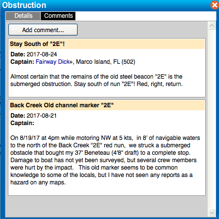
Note the dates. The incident occurred only four days prior to me seeing this. This was quite a learning point for my client who I introduced to Active Captain back when we first started looking at boats. Later in the day while the boat was in the slings during haulout, we discovered our sea trial Captain knew all about it, and in fact had pictures on his phone of the damage to this boat. The damage was severe and will be very costly to address. Very unfortunate, indeed.
I think the key take-aways are
- There is good water in the vicinity of that ATON. It is understandable given the charted depths how someone might be lulled into complacency, but… ‘red right returning’.
- Encouragingly, the mishap Captain did the right thing and posted the issue to Active Captain, showing the true worth of the crowd sourced approach to providing information, good or bad.
And here is the real point.
- How is anyone not familiar with ‘local common knowledge’ going to know about the hazard without Active Captain?
What about NOTAMS you say? Well, the issue is noted, somewhat cryptically, in the USCG District 5 local notice to mariners , on page 6 of 36, with the following verbiage

STRUCT DEST/HAZ NAV/TRLB translates as “structure destroyed / hazard to navigation / temporarily replaced by lighted bouy”. Let’s be honest, how many recreational boaters take the time to complete a local NOTAM review, at best a burdensome task? Even if this Captain had reviewed all pertinent local NOTAMS how would he have known the specific location and nature of this hazard without referring to Active Captain?
An unfortunate story, but one that puts an explanation point on why you should be using this invaluable resource.

I read about this obstruction yesterday (10/22/2017). I have just returned from a day-sail, and noticed that “2E” is now mounted on a what looks like a steel pilling.
I have been using “2E” as a way-point for getting into Back Creek, which is my home berth. I draw 18″ (center board up) and 4.5′ with the board down. Because the spot soundings are 7′ or more, I often treat “2E” as a center-channel marker, available to me coming from the North or the South. I have no doubt that I have probably sailed right over the obstruction.